Exhibit A · Section 3
The flight computer that took off in Ethiopia
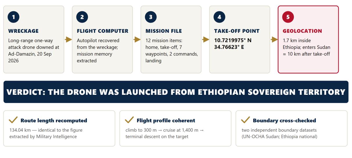
The single most decisive item of evidence is a flight computer. It records, in its own memory, where the drone that carried it took off. That place is in Ethiopia.
Recovery
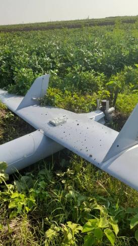
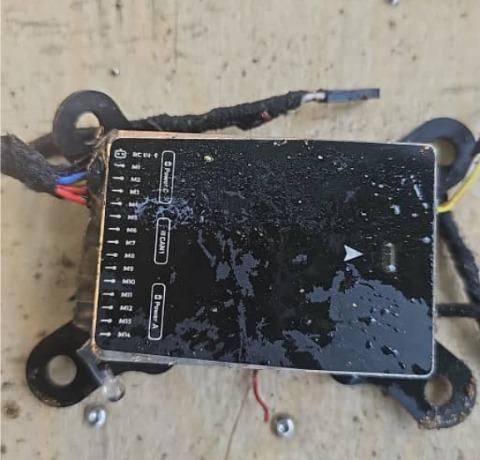
On 20 September 2026 the Sudanese Armed Forces brought down a long-range, fixed-wing one-way attack drone at Ad-Damazin, the capital of Blue Nile State. The aircraft has a wingspan of 5.3 m and a fuselage length of 3.2 m, is powered by a petrol engine, carries a 35 kg explosive warhead, is fitted with an anti-jamming module and has a range of about 1,000 km. Its autopilot, the flight-control computer that stores and executes the pre-programmed mission, was recovered from the wreckage and its memory extracted by Sudanese specialists.
What the memory contains
The autopilot holds a complete mission of twelve items, written in the standard MAVLink mission format used by open-architecture flight controllers. The mission defines a take-off, a climb, a cruise at 1,400 m, a programmed servo command and a terminal descent onto a target in the Ad-Damazin area.
| Item | Command | Coordinates | Altitude | Function |
|---|---|---|---|---|
| 0 | NAV_WAYPOINT (home) | - | 0 m | Reference position set before launch |
| 1 | NAV_TAKEOFF | 10.7219975° N, 34.7662300° E | 80 m | Take-off, on Ethiopian territory; climb at an initial 8° pitch |
| 2 | NAV_WAYPOINT | 10.7343203° N, 34.7437477° E | 300 m | Steep climb, still over Ethiopian territory |
| 3 | DO_MOUNT_CONTROL | - | 300 m | Camera gimbal set: roll −180°, pitch and yaw 0° |
| 4 | NAV_WAYPOINT | 10.8584266° N, 34.7004890° E | 1,400 m | Main climb completed, now over Sudan |
| 5 | NAV_WAYPOINT | 11.0685813° N, 34.5410156° E | 1,400 m | Cruise |
| 6 | NAV_WAYPOINT | 11.2928944° N, 34.3988800° E | 1,400 m | Cruise |
| 7 | DO_SET_SERVO | - | 1,400 m | Servo channel 7 actuated (PWM 2000): payload or device activation |
| 8 | NAV_WAYPOINT | 11.4726226° N, 34.2982864° E | 1,400 m | Cruise |
| 9 | NAV_WAYPOINT | 11.6295388° N, 34.2193222° E | 1,400 m | North-western turning point |
| 10 | NAV_WAYPOINT | 11.6938019° N, 34.2709494° E | 1,188 m | Descent begins towards the target |
| 11 | NAV_LAND | 11.7352399° N, 34.3167910° E | 488 m | Terminal approach on the target |
Geolocation of the take-off point
The drone took off from Ethiopian territory. This conclusion rests on clear and mutually confirming evidence, and admits no other reading.
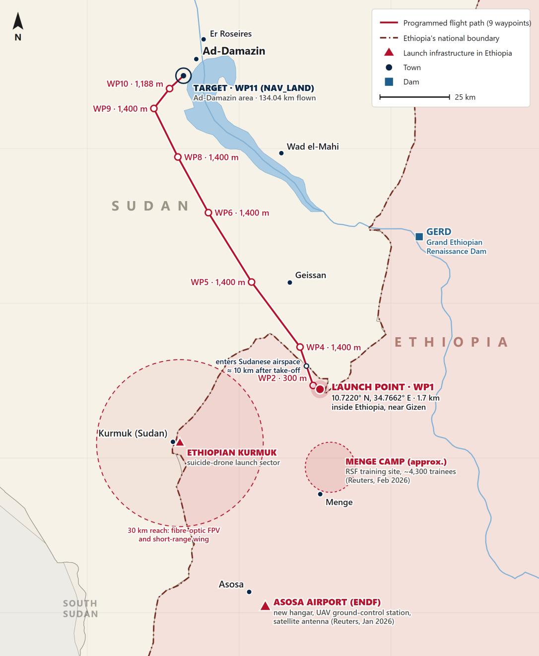
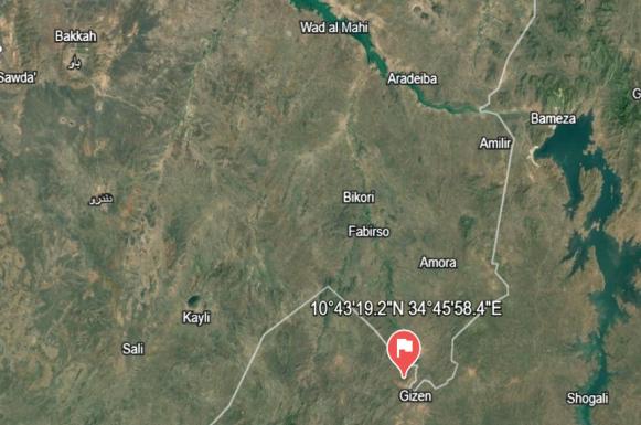
The take-off coordinates, 10.7219975° N, 34.7662300° E, lie near the Ethiopian locality of Gizen, opposite the Sudanese district of Geissan. Their location on the Ethiopian side of the boundary is established by three independent means:
- The aircraft's own record. The coordinates are not an estimate or a reconstruction. They are the take-off position written into the mission stored in the drone's flight-control computer, recovered from the wreckage at Ad-Damazin.
- Satellite geolocation. Plotted on satellite imagery, the coordinates place the take-off point on the Ethiopian side of the boundary, beside Gizen (Figure 4).
- Measurement against two boundary datasets. The Government of Sudan measured the coordinates against the administrative boundary of Sudan maintained for the United Nations Office for the Coordination of Humanitarian Affairs and against the national boundary of Ethiopia.11 Both datasets agree: the take-off point lies 1.7 km inside Ethiopia and 1.8 km beyond the boundary of Sudan.
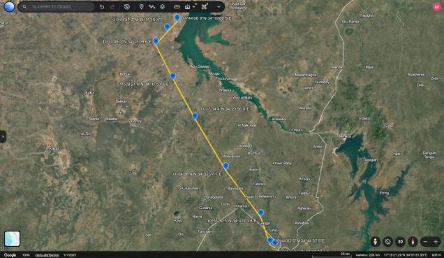
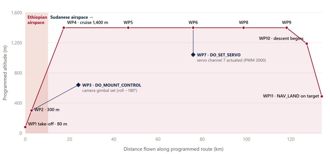
The conclusion does not rest on a single point. The take-off, the climb to the second waypoint at 300 m, itself between 2.3 and 3.4 km inside Ethiopia, and the first ten kilometres of the programmed route all lie over Ethiopian territory; the drone was programmed to enter Sudanese airspace only about ten kilometres after take-off. The launch site lies 65 km from the Grand Ethiopian Renaissance Dam, in one of the most closely guarded security zones in Ethiopia.
Integrity of the data
A fabricated or corrupted flight plan would betray itself. This one does not. Three independent checks confirm its integrity:
- Route length. Summing the great-circle distances between the nine positional waypoints gives 134.04 km, identical, to the hundredth of a kilometre, to the figure reported.
- Flight profile. The altitudes form a coherent operational profile: a climb to 300 m, a climb to a 1,400 m cruise, and a staged descent onto the target. The commands are correctly sequenced.
- Geography. Every waypoint after the border crossing lies inside Sudan along a direct corridor to Ad-Damazin; the target point lies in the Ad-Damazin area, where the aircraft was brought down.
Finding A
The drone that attacked Ad-Damazin on 20 September 2026 was launched from Ethiopian territory. Its pre-programmed mission records a take-off point 1.7 km inside Ethiopia; satellite geolocation and two independent boundary datasets confirm it. Its operators stood on Ethiopian soil, 65 km from the GERD, in a zone under the full control of the Ethiopian security forces. This is not inference. It is the aircraft's own record, confirmed.